
Utrecht stories · History
The Empty Space the Storm Left Behind
How one violent evening destroyed the middle of Utrecht’s cathedral—and eventually created Domplein.
1254–1674
Documented fact
The church that filled the square
Domplein, Utrecht · 52.0907, 5.1214
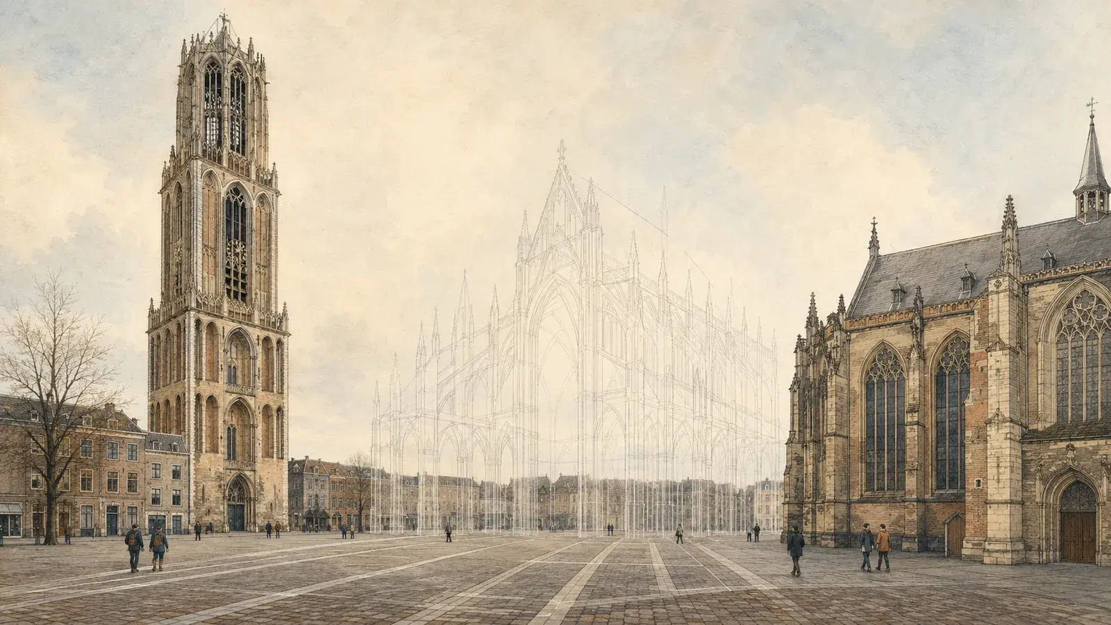
To picture the Dom before the storm, begin by removing Domplein. The tower did not stand across a civic square from the church. Between them rose the nave: the long central body of the cathedral, extending over the ground people now cross on foot.
Construction of the Gothic Domkerk began in 1254 as a replacement for an earlier Romanesque cathedral. It proceeded over centuries. The tower was completed in 1382; work continued on the choir, transept and finally the nave.
By 1517, Utrecht’s heritage service says, the nave was broadly complete. One major part of the intended design remained unfinished: its planned stone vaulting and the flying buttresses associated with it. Income from indulgences declined during the Reformation era, and the same municipal account says the work stopped in 1526.
That unfinished state is often presented as the simple reason the nave later collapsed. The evidence supports more caution. The missing elements are documented, but an architectural note in the Canon van Nederland observes that the timber-roofed construction could itself be sturdy. It questions whether completing the stone vaults and buttresses would have saved the building in 1674.
The secure fact is less dramatic but more useful: on the eve of the storm, Utrecht’s cathedral was a building assembled across generations, with a nave that did not match the full design once intended for it.
Evidence and sources (2)
- Domplein
Supports the 1254 start, the broad completion of the nave in 1517, the missing vaulting and associated flying buttresses, and work stopping in 1526.
Gemeente Utrecht — Erfgoed Utrecht · Accessed - Het schip van de Dom
Supports the caution that the unfinished elements cannot be treated as a proven cause of the later collapse.
Canon van Nederland · Accessed
- Domplein
1 August 1674
Documented fact
A summer evening turns violent
Domplein, Utrecht · 52.0907, 5.1214
Wednesday 1 August 1674 was warm and oppressive. In the early evening, a line of exceptionally severe thunderstorms reached Utrecht. The worst of the storm struck the city between about seven and half past seven.
The damage went far beyond the Dom. KNMI’s historical reconstruction describes church towers, mills, roofs and trees being destroyed across Utrecht and surrounding towns. Period reports conveyed the speed and confusion of the event: thunder, violent winds and destruction concentrated into a short period. Later generations remembered it as ’t Schrickelik Tempeest—the terrible tempest.
The middle of the Domkerk collapsed between the tower and the surviving transept and choir. The event altered not only one building but Utrecht’s skyline. Other church towers were damaged, yet the Domtoren emerged with virtually no damage.
There were no weather instruments in Utrecht capable of recording the winds that evening. Modern researchers have instead reconstructed the storm from contemporary writing, mapped damage and images. A peer-reviewed study by KNMI researchers Gerard van der Schrier and Rob Groenland describes an exceptionally severe squall line with a bow-shaped section and powerful downbursts. Their wind figures are estimates derived from damage, not measurements taken at the cathedral.
That distinction matters. The historical evidence can show what was destroyed. Modern meteorology can offer the best available explanation. Neither can replay every second above Domplein.
Evidence and sources (2)
- Zomerstorm van 1674: Domkerk Utrecht stort in
Supports the timing, citywide damage, contemporary evidence and downburst reconstruction.
KNMI · Accessed - A reconstruction of 1 August 1674 thunderstorms over the Low Countries
Supports the severe squall-line and bow-echo interpretation and the damage-based nature of wind estimates.
Natural Hazards and Earth System Sciences · Accessed
- Zomerstorm van 1674: Domkerk Utrecht stort in
1674
Interpretation
The missing middle
Domplein, Utrecht · 52.0907, 5.1214
The immediate puzzle is obvious from the square today. How could the nave fall while the much taller Domtoren remained standing nearby?
Older accounts supplied a neat answer: a tornado crossed the nave or the unfinished church was simply weaker. Current research is less tidy. KNMI and Gemeente Utrecht emphasize the highly localized character of downbursts and the vortices that can form around them. Within a short distance, one place can receive devastating wind while another receives much less.
Utrecht’s heritage service applies that explanation directly to the Dom complex. The strongest wind hit the nave, while the tower, transept and choir were exposed to less severe gusts. It describes the tower’s survival as luck and explicitly rejects the idea that it survived because it was stronger than the church.
This does not settle every architectural question. The nave lacked parts of its intended design, and the tower was a different structure. But no inspected engineering source demonstrates a complete chain of failure, or proves that the tower’s construction caused its survival.
The most defensible answer therefore begins with the storm, not the stonework: the destructive wind field was narrow and uneven. Utrecht’s defining landmark remained standing a few metres from the section that received the full force.
Evidence and sources (3)
- Domplein
Supports the localized-wind explanation and the explicit rejection of superior tower strength.
Gemeente Utrecht — Erfgoed Utrecht · Accessed - Zomerstorm Utrechtse Dom in 1674
Explains downbursts, local vortices and sharp contrasts in damage.
KNMI · Accessed - Hoe de Domtoren een verwoestend noodweer overleefde
States that the nave received the strongest winds while the tower happened to receive less.
KNMI · Accessed
- Domplein
1677–1823
Documented fact
A ruin behind a wall
Domplein, Utrecht · 52.0907, 5.1214
The collapse did not immediately produce a square. First it produced a problem of ownership, money and repair.
The Domkapittel—the chapter that owned the church—had insufficient funds to rebuild the nave. Utrecht’s municipal history records a long delay before work began on the surviving building. Only in 1677, after pressure from the city government, did the chapter start closing the exposed church.
Materials from the fallen nave became part of the solution. Lead, copper and natural stone were sold to help finance the work. By 1683, the surviving church had been sealed with a new masonry wall. The nave was not coming back. Beyond that wall remained a stripped and enclosed ruin.
Herman Saftleven preserved some of what Utrecht had lost. Between 1674 and 1677 he produced twenty drawings of the ruined Domkerk and Pieterskerk, together with a title page and register. In August 1682, Utrecht’s city government bought the complete series for 250 guilders. An RKD study of the archival record concludes that he made the drawings on his own initiative before selling them to the city.
Those sheets matter because the ruin itself outlasted the people who first saw it. It remained part of central Utrecht into the nineteenth century: neither restored as a cathedral nor immediately cleared for a new use.
Evidence and sources (3)
- Domplein
Supports the financial constraints, sale of materials, the 1677 start and the 1683 completion of the enclosure.
Gemeente Utrecht — Erfgoed Utrecht · Accessed - Domtoren
Supports the sale of materials and enclosure of the surviving church after the nave collapsed.
Gemeente Utrecht — Erfgoed Utrecht · Accessed - Herman Saftleven — 1.4 Late jaren
Supports the twenty-drawing series, its dates, the 1682 sale and the conclusion that it was not originally a city commission.
RKD Studies · Accessed
- Domplein
1823–1912
Documented fact
The ruin becomes a square
Domplein, Utrecht · 52.0907, 5.1214
The change began with a transfer. In 1823, the Domkerk, the nave ruin, the churchyard and several related buildings passed to Utrecht’s Reformed congregation. Three years later, the congregation sold the ruin to the city.
Demolition began in 1826. By the following year, the remaining structure and debris had been cleared and Utrecht had an open space between tower and church. The physical relationship that now seems inseparable from the city—a solitary tower facing the shortened cathedral—was finally established more than 150 years after the storm.
The city tried to put the new space to work. A vegetable market moved there after clearance, but traders disliked the strong wind funnelled between tower and church. The market returned to Mariaplaats a year later.
Even then, the space was not yet called Domplein. That official name arrived only in 1912. By that point the temporary absence caused by a disaster had become a permanent part of Utrecht’s map.
The square was therefore created through two events separated by generations: destruction in 1674 and municipal clearance in the 1820s. The storm made the gap. Utrecht’s later decision not to preserve the remaining ruin made the open space.
Evidence and sources (2)
- Domplein
Supports the 1823 transfer, 1826 sale and demolition, completion the following year, the brief vegetable market and the 1912 name.
Gemeente Utrecht — Erfgoed Utrecht · Accessed - Domplein revisited
Supports the broad archaeological chronology of the former nave site, the creation of the open space and the later name.
Gemeente Utrecht — Erfgoed Utrecht · Accessed
- Domplein
1912–present
Documented fact
Walking the vanished nave
Domplein, Utrecht · 52.0907, 5.1214
Domplein is open, but the missing building has not disappeared completely.
On the surface, paving marks the former nave. The lines allow a visitor standing between tower and church to read the square as a floor plan: not simply empty ground, but the central body of a cathedral.
Below it, the evidence is physical. Archaeological work associated with DOMunder documented a surviving Gothic nave pier and walls, alongside remains from earlier churches and the Roman fort beneath the square. The site is layered because Utrecht repeatedly built its religious centre over what came before—and because the 1674 collapse stopped one of those layers at ground level.
Saftleven’s drawings add another way of seeing. They show broken piers, exposed interiors and the intact tower beyond the wreckage. Paired with the paving and archaeology, they make it possible to move between three versions of the same place: cathedral, ruin and square.
That is the lasting surprise of Domplein. Utrecht did not set out to create a ceremonial gap between its tower and church. The city inherited one from a storm, enclosed it, lived beside it for generations and eventually cleared it. Today, every crossing of the square passes through the vanished middle of the Dom.
Evidence and sources (3)
- Zomerstorm Utrechtse Dom in 1674
Supports the statement that the paving reveals where the nave piers stood.
KNMI · Accessed - DOMunder: Archeologisch onderzoek in het hart van Utrecht
Supports the preservation of a Gothic nave pier and walls below the square.
Gemeente Utrecht — Erfgoed Utrecht · Accessed - Herman Saftleven — 1.4 Late jaren
Supports the identity and archival preservation of Saftleven’s ruin series.
RKD Studies · Accessed
- Zomerstorm Utrechtse Dom in 1674
Sources
- DompleinGemeente Utrecht — Erfgoed Utrecht
- Het schip van de DomCanon van Nederland
- Zomerstorm van 1674: Domkerk Utrecht stort inKNMI
- A reconstruction of 1 August 1674 thunderstorms over the Low CountriesNatural Hazards and Earth System Sciences
- Zomerstorm Utrechtse Dom in 1674KNMI
- Hoe de Domtoren een verwoestend noodweer overleefdeKNMI
- DomtorenGemeente Utrecht — Erfgoed Utrecht
- Herman Saftleven — 1.4 Late jarenRKD Studies
- Domplein revisitedGemeente Utrecht — Erfgoed Utrecht
- DOMunder: Archeologisch onderzoek in het hart van UtrechtGemeente Utrecht — Erfgoed Utrecht